Glacial Valleys and Their Distinctive Shapes
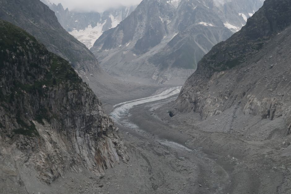
Glacial valleys are among the most recognizable landforms in mountainous regions, characterized by their broad, U-shaped cross-sections, steep walls, and relatively flat floors. Unlike river valleys, which typically exhibit a narrower V-shaped profile, glacial valleys reflect the distinct erosional processes of ice masses moving slowly downslope over long periods. Understanding these differences provides insight into past climate conditions and the dynamic history of mountain landscapes.
The formation of glacial valleys involves a combination of abrasion, plucking, and subglacial meltwater activity that gradually modifies pre-existing topography. As ice accumulates and flows, it scours the underlying bedrock, widening and deepening the valley while smoothing irregularities. This process contrasts with fluvial erosion, where water primarily cuts downward and laterally, creating a more angular V-shaped form. The resulting shapes are not merely aesthetic; they influence drainage patterns, sediment transport, and ecological habitats.
This article examines the principal features of glacial valleys—U-shaped troughs, cirques, and hanging valleys—and contrasts them with river-formed V-shaped valleys. It discusses the processes that produce these landforms, the factors that influence their development, and the broader context in which they appear. The focus is on explaining the mechanisms and characteristics rather than predicting specific outcomes, recognizing that many variables affect the final morphology.
How Glaciers Carve U-Shaped Valleys
Glacial erosion operates through several mechanisms that collectively produce a U-shaped valley. At the base of a glacier, rock fragments embedded in the ice abrade the bedrock, acting like sandpaper to smooth and polish the surface. Simultaneously, plucking occurs when meltwater freezes around bedrock outcrops, and subsequent ice movement pulls loose blocks away. These processes are most effective where ice is thick and moves relatively fast, often in the upper reaches of a valley. Over time, the repeated cycles of abrasion and plucking widen the valley floor and steepen the walls, resulting in a characteristic U-shaped profile.
The cross-sectional shape of a glacial valley is also influenced by the ice’s ability to erode laterally. Unlike a river, which concentrates erosion along a narrow channel, a glacier fills the entire valley width, exerting pressure on both sides. This lateral erosion is particularly pronounced where the ice is confined by topography, leading to a broad, flat floor. The transition from a V-shaped to a U-shaped profile may occur gradually as ice advances and retreats, and the degree of modification depends on the duration of glacial occupation and the resistance of the bedrock.
Several factors determine the rate and extent of U-shaped valley development. These include:
- Ice thickness and velocity, which control the energy available for erosion.
- Bedrock lithology and structure, which affect resistance to abrasion and plucking.
- Pre-existing topography, which guides ice flow and determines where erosion is concentrated.
- Subglacial hydrology, which influences meltwater distribution and basal sliding.
- Duration of glaciation, as longer periods allow more extensive modification.
It is important to note that not all glacial valleys are perfectly U-shaped. Variations in these factors can produce asymmetric profiles, stepped floors, or overdeepened basins. Such features are common in many mountain ranges and provide evidence of complex glacial histories. The presence of a U-shaped valley does not guarantee that a glacier is currently active; many such valleys are relict, formed during past ice ages and later modified by other processes.
Cirques: Birthplaces of Glacial Valleys
Cirques are bowl-shaped depressions that often serve as the starting points for glacial valleys. They form at the heads of valleys where snow accumulates and compacts into ice. As the ice mass grows, it erodes the surrounding bedrock through a combination of frost shattering, plucking, and abrasion. The result is a steep-walled, concave basin with a flat or gently sloping floor. Cirques are typically found at high elevations and may contain small lakes, known as tarns, after the ice retreats.
The development of a cirque involves both headward erosion and deepening. Headward erosion extends the cirque backward into the mountain, while deepening occurs as ice continues to scour the floor. Over multiple glacial cycles, cirques can enlarge and coalesce, contributing to the retreat of mountain ridges and the formation of arêtes—narrow, sharp crests between adjacent cirques. The presence of a well-developed cirque indicates that a glacier existed long enough to modify the landscape significantly, though the exact timing and duration require careful geological dating.
Cirques are not isolated features; they are integral to the glacial valley system. As ice flows out of a cirque, it enters the main valley and begins to carve a U-shaped trough. The transition from cirque to valley may be marked by a steep headwall or a series of rock steps. In some cases, multiple cirques feed into a single valley, creating a complex network of tributary glaciers. This interconnectedness highlights the importance of understanding cirques when interpreting the broader glacial history of a region.
Factors that influence cirque morphology include aspect, elevation, and climate. North-facing cirques in the Northern Hemisphere, for example, often receive less solar radiation and may retain snow longer, favoring glacier development. However, local topography and prevailing winds also play a role. The shape and size of a cirque can thus vary considerably from one mountain range to another, reflecting the interplay of climate and geology.
Hanging Valleys and Their Formation
Hanging valleys are tributary valleys that enter a main glacial trough at an elevation above the main valley floor. They form because the main glacier, being larger and thicker, erodes its valley more deeply than the smaller tributary glaciers. When the ice retreats, the tributary valley is left “hanging” above the main valley, often with a steep cliff or waterfall at its mouth. This distinctive feature is a hallmark of glacial landscapes and provides clear evidence of differential erosion.
The formation of hanging valleys depends on the relative size and erosive power of the main and tributary glaciers. A large, fast-moving trunk glacier can incise its valley by hundreds of meters, while smaller tributary glaciers may only deepen their valleys modestly. The resulting elevation difference can range from a few meters to over a hundred meters. In some cases, multiple hanging valleys occur along a single main valley, each representing a former tributary glacier of varying size.
Hanging valleys are not static features; after glaciation, they may be modified by rivers, debris flows, or further glacial advances. Waterfalls often develop where streams from hanging valleys plunge into the main valley, creating scenic attractions and influencing local hydrology. The presence of hanging valleys also affects sediment delivery and ecosystem patterns, as the elevated tributaries may have different microclimates and vegetation compared to the main valley floor.
Recognizing hanging valleys in the field requires careful observation of valley profiles and the identification of truncated spurs—ridge lines that have been cut off by the main glacier. These spurs, combined with the elevated tributary mouths, are strong indicators of glacial erosion. However, similar features can be produced by faulting or landslides, so a combination of evidence is typically needed to confirm a glacial origin. The study of hanging valleys thus contributes to a more nuanced understanding of landscape evolution.
Contrasting Glacial and River Valleys
The contrast between glacial and river valleys is fundamental to geomorphology. River valleys are primarily shaped by flowing water, which erodes vertically and laterally, creating a V-shaped cross-section. The steepness of the valley walls depends on the balance between downcutting and hillslope processes. In contrast, glacial valleys are carved by ice, which erodes both downward and sideways, producing a U-shaped profile with a broad floor and steep, often polished walls. This difference in shape reflects the distinct mechanics of erosion: water concentrates its energy in a narrow channel, while ice exerts pressure across the entire valley width.
Another key difference lies in the longitudinal profile. River valleys typically have a smooth, concave-up profile that grades from steep headwaters to gentler lower reaches. Glacial valleys often exhibit a stepped profile with overdeepened basins, rock bars, and reversed gradients. These irregularities result from variations in ice thickness, bedrock resistance, and subglacial meltwater erosion. Such features can persist long after the ice has disappeared, influencing subsequent river patterns and sedimentation.
The transition from a river valley to a glacial valley can occur when a glacier advances into a previously fluvial landscape. The glacier may entirely reshape the valley, or it may only modify certain sections, depending on the size and duration of the ice advance. In some cases, the resulting landscape is a palimpsest, with glacial features superimposed on older river valleys. Understanding this interplay requires integrating evidence from landforms, sediments, and dating methods.
From a practical perspective, the shape of a valley affects human activities such as transportation, settlement, and resource management. U-shaped valleys often provide flat floors suitable for roads and agriculture, while their steep walls can pose challenges for construction. V-shaped valleys, with their narrower floors, may be more prone to flash flooding and debris flows. Recognizing the origin of a valley can thus inform land-use planning and hazard assessment, though it is only one of many factors to consider.
Interpreting Glacial Landscapes
Interpreting glacial landscapes involves more than identifying U-shaped valleys, cirques, and hanging valleys. It requires an understanding of the processes that formed them and the context in which they occur. Geologists use a combination of field observations, remote sensing, and dating techniques to reconstruct glacial histories. Features such as moraines, erratics, and striations provide additional clues about ice extent and flow direction.
When examining a mountain landscape, it is useful to consider the following questions:
- What is the overall shape of the valley—U-shaped, V-shaped, or something else?
- Are there cirques at the valley heads, and do they show signs of multiple glaciations?
- Do tributary valleys enter at higher elevations, suggesting hanging valleys?
- What is the nature of the valley floor—smooth, stepped, or overdeepened?
- Are there sedimentary deposits that indicate glacial or fluvial transport?
Answering these questions can help distinguish between glacial and non-glacial origins. However, it is important to avoid overgeneralization; not all U-shaped valleys are glacial, and not all glacial valleys are perfectly U-shaped. The complexity of Earth surface processes means that multiple explanations may be possible, and a cautious, evidence-based approach is warranted.
Summit Ridge recognizes the value of careful observation and interdisciplinary research in understanding mountain landscapes. By integrating geological, climatic, and ecological data, researchers can build more robust interpretations of how valleys form and evolve. This knowledge contributes to broader discussions about landscape dynamics, natural hazards, and environmental change, without implying specific outcomes for any particular location.
In summary, glacial valleys and their distinctive shapes are the product of complex interactions between ice, bedrock, and climate. U-shaped valleys, cirques, and hanging valleys each reflect specific erosional processes that differ from those of river-formed V-shaped valleys. Recognizing these features enhances our appreciation of mountain geomorphology and provides a foundation for further study. The interpretation of any landscape should remain flexible, acknowledging the many factors that can influence its development over time.